


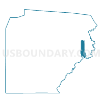
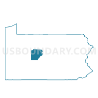
COOPER TWP PCT 02, Clearfield County, Pennsylvania
About
Outline

Summary
| Unique Area Identifier | 658633 |
| Name | COOPER TWP PCT 02 |
| County | Clearfield County |
| State | Pennsylvania |
| Area (square miles) | 10.16 |
| Land Area (square miles) | 10.11 |
| Water Area (square miles) | 0.05 |
| % of Land Area | 99.49 |
| % of Water Area | 0.51 |
| Latitude of the Internal Point | 41.00332750 |
| Longtitude of the Internal Point | -78.16012980 |
Maps

Graphs
Select a template below for downloading or customizing gragh for COOPER TWP PCT 02, Clearfield County, Pennsylvania


Neighbors
Neighoring Voting District (by Name) Neighboring Voting District on the Map
- COOPER TWP PCT 01, Clearfield County, PA
- COVINGTON TWP Voting District, Clearfield County, PA
- GRAHAM TWP Voting District, Clearfield County, PA
- MORRIS TWP PCT 01, Clearfield County, PA
- MORRIS TWP PCT 02, Clearfield County, PA
- RUSH TWP VTD EAST, Centre County, PA
Top 10 Neighboring County Subdivision (by Population) Neighboring County Subdivision on the Map
- Rush township, Centre County, PA (4,008)
- Morris township, Clearfield County, PA (2,938)
- Cooper township, Clearfield County, PA (2,704)
- Graham township, Clearfield County, PA (1,383)
- Covington township, Clearfield County, PA (526)
Top 10 Neighboring Place (by Population) Neighboring Place on the Map
Top 10 Neighboring Unified School District (by Population) Neighboring Unified School District on the Map
- Clearfield Area School District, PA (19,134)
- Philipsburg-Osceola Area School District, PA (15,412)
- West Branch Area School District, PA (7,865)
Top 10 Neighboring State Legislative District Lower Chamber (by Population) Neighboring State Legislative District Lower Chamber on the Map
Top 10 Neighboring State Legislative District Upper Chamber (by Population) Neighboring State Legislative District Upper Chamber on the Map
Top 10 Neighboring 111th Congressional District (by Population) Neighboring 111th Congressional District on the Map
Top 10 Neighboring Census Tract (by Population) Neighboring Census Tract on the Map
- Census Tract 3308, Clearfield County, PA (7,025)
- Census Tract 104, Centre County, PA (3,598)
- Census Tract 3307, Clearfield County, PA (2,306)
Top 10 Neighboring 5-Digit ZIP Code Tabulation Area (by Population) Neighboring 5-Digit ZIP Code Tabulation Area on the Map
- 16858, PA (3,688)
- 16836, PA (1,152)
- 16879, PA (532)
- 16860, PA (451)
- 16847, PA (335)
- 16849, PA (331)
- 16834, PA (299)